Fort Hancock and Battery Gunnison/New Battery Peck
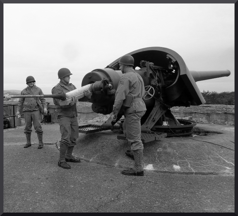
Modern photo of AGFA members demonstrating loading of the M1900 6-inch gun. Credit: AGFA
Battery Gunnison/New Battery Peck GPS Address: 399 Gunnison Rd, Highlands, NJ 07732
Virtual Tour of Battery Gunnison/New Peck
NPS Fort Hancock and Sandy Hook National Proving Ground Historic Landmark Map (Area Overview)
Cultural Landscape Report for the Sandy Hook Coastal Defense Batteries
NPS Fort Hancock Historic Post Map
TM 4-210 Coast Artillery Weapons
1944 Fort Hancock Map
Fort Hancock and Sandy Hook Proving Ground National Historic Landmark District Inventory
The map linked below is the final Chief of the Corps of Engineers approved (June 1980) real property turnover map of Fort Hancock. It shows the entire Sandy Hook peninsula was named Fort Hanock at the time of its closure and transfer to the Secretary of Interior. It also shows previous transfers to the Secretary of the Treasury (for the US Coast Guard) and other transfers to the State of New Jersey. The bulk of the transfer was to the Secretary of the Interior.
The Eastern Defense Command was headquartered at Governors Island in New York Harbor. It was responsible for the defense of the entire eastern seaboard of the United States. The seriousness the US took the threat from Axis Forces (Germany, Italy and Japan) is clear in these two documents from May and September 1942. The proclamations describe Prohibited Zones and Restricted Zones in detail and what actions are permissible and not permissible in each zone. These documents were issued to the public so all citizens and officials understood what was expected of them by the Commander, Eastern Defense Command (Lieutenant General Hugh Drum) base on authority granted to him by President Roosevelt and Acts of Congress. The descriptions of the Prohibited and Restricted Zones are important. In short, all Prohibited Zones were locations occupied by the military for defense or other wartime purposes. The list of items not allowed (absent permissions) in Prohibited zones includes cameras, recording devices, weapons, weapons parts and ammunition. The Restricted Zones did not restrict weapons, but did restrict cameras. Restricted zones were areas that either provided access to the enemy (shore lines, docks and landing fields) or were important for national security purposes but were other than military installations. Many citizens lived in restricted zones. It is fairly easy to see from the maps in these documents that our entire coast line was a restricted zone.
HQ Eastern Defense Command Proclamation #1
HQ Eastern Defense Command Proclamation #2
Corps of Engineers Real Property Transfer Map - Approved 1980
The Eastern Defense Command was headquartered at Governors Island in New York Harbor. It was responsible for the defense of the entire eastern seaboard of the United States. The seriousness the US took the threat from Axis Forces (Germany, Italy and Japan) is clear in these two documents from May and September 1942. The proclamations describe Prohibited Zones and Restricted Zones in detail and what actions are permissible and not permissible in each zone. These documents were issued to the public so all citizens and officials understood what was expected of them by the Commander, Eastern Defense Command (Lieutenant General Hugh Drum) base on authority granted to him by President Roosevelt and Acts of Congress. The descriptions of the Prohibited and Restricted Zones are important. In short, all Prohibited Zones were locations occupied by the military for defense or other wartime purposes. The list of items not allowed (absent permissions) in Prohibited zones includes cameras, recording devices, weapons, weapons parts and ammunition. The Restricted Zones did not restrict weapons, but did restrict cameras. Restricted zones were areas that either provided access to the enemy (shore lines, docks and landing fields) or were important for national security purposes but were other than military installations. Many citizens lived in restricted zones. It is fairly easy to see from the maps in these documents that our entire coast line was a restricted zone.
HQ Eastern Defense Command Proclamation #1
HQ Eastern Defense Command Proclamation #2
Home